Covering genealogy, family history, historical events and places, and anything else related!

Showing posts with label Mappy Monday. Show all posts

Monday, January 9, 2017

Mappy Monday: Cairo, Illinois and Vicinity, 1861

Viele, Egbert Ludovicus. H.H. Lloyd & Co's campaign military charts showing the principal strategic places of interest. H.H. Lloyd & Co., 1861. Public domain. Available from Wikimedia Commons.

My 3rd-great-grandfather Davidson Binkley died of measles 154 years ago today, on 9 January 1863, in Cairo, Alexander County, Illinois, while he was serving in Company G, 128th Illinois Infantry. This map shows the area where he was stationed, and where he died.

Monday, November 14, 2016

Mappy Monday: Baden 1801-1819

Baden 1801-1819. By ziegelbrenner [GFDL (http://www.gnu.org/copyleft/fdl.html), CC-BY-SA-3.0 (http://creativecommons.org/licenses/by-sa/3.0/) or CC BY 2.5 (http://creativecommons.org/licenses/by/2.5)]. Available from Wikimedia Commons.

This map shows Baden from 1801 to 1815, and indicates when areas became part of Baden. My ancestors lived in the area that became part of Baden in 1805.

Monday, October 24, 2016

Mappy Monday: Bass Islands, Lake Erie

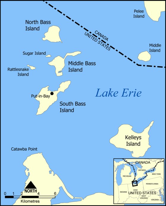
Map of the Bass Islands in Lake Erie. By NormanEinstein CC BY-SA 3.0 (http://creativecommons.org/licenses/by-sa/3.0). Available from Wikimedia Commons.

This map shows the location of the Bass Islands, which are in the western half of Lake Erie, and are part of Ottawa County, Ohio.

My 5th-great-grandfather Andrew Russell was a private in Tunstall Quarles' Company of Infantry, 2nd Regiment Kentucky Volunteer Militia during the War of 1812. His regiment formed on 1 September 1812. By mid-September, they reached General William Henry Harrison's headquarters in St. Marys, Ohio. They then proceeded north and began the construction of Fort Jennings. After the fort was completed, the regiment remained on garrison duty for a few months. They then headed north to Put-in-Bay, which is located on South Bass Island. The U.S. had suffered defeats in and near the western Lake Erie area at the beginning of the war. Andrew's regiment may have been sent north to help increase the U.S. military presence in the area. They were eventually sent back to Cincinnati because their term of service was coming to an end. I am not sure how much time Andrew spent in Put-in-Bay. South Bass Island has been called the "Key West of Lake Erie," but surely it did not seem that way to Andrew and the other men during the winter of 1813.

Monday, September 12, 2016

Mappy Monday: Provinces of Götaland, Sweden

Map of Götaland, showing the smaller regions (landskap). CC BY-SA 3.0 (http://creativecommons.org/licenses/by-sa/3.0). Available from Wikimedia Commons.

This map shows the provinces that make up Götaland, one of the three lands of Sweden. All of my known Swedish ancestors came from Götaland.

Monday, August 15, 2016

Mappy Monday: Map of the East Tennessee, Virginia and Georgia Railroad and Connections

Map of the East Tennessee, Virginia and Georgia Railroad and Connections. From East Tennessee, Virginia and Georgia Railroad Company. Guide to the Summer Resorts and Watering Places of East Tennessee. Memphis: Memphis, S.C. Toof, 1880. Available from Flickr and Wikimedia Commons

This map shows the East Tennessee, Virginia and Georgia Railroad in its connections.

Monday, August 1, 2016

Mappy Monday: Map of Montreal, 1700

Carte De l'ile Montreal, 1700. Travail des sulpiciens. Public domain. Available from Wikimedia Commons.

This map shows the island of Montreal in 1700. The forts in the area became towns and villages.

Monday, July 18, 2016

Mappy Monday: Johnson's Minnesota and Dakota, 1862

Johnson's Minnesota and Dakota. Johnson, A. J., Johnson's New Illustrated (Steel Plate) Family Atlas with Descriptions, Geographical, Statistical, and Historical. A. J. Johnson & Ward, 1862. Public domain. Available from Wikimedia Commons.

This map shows Minnesota and the Dakota Territory in 1862. Just a few years later, in 1866 and 1867, my Boe and Halvorson-Otterholt ancestors left Norway and settled in Dodge County, Minnesota.

Monday, July 11, 2016

Mappy Monday: Plan of a Mediaeval Manor

Shepherd, William R. Plan of a Mediaeval Manor. Historical Atlas. New York: Henry Holt and Company, 1923. Public domain. Available from Wikimedia Commons.

I have been attempting to transcribe the 1644 will of my 10th-great-grandfather John Woodley from Widdington, Essex, England. I thought it might be helpful to look at the terminology used for English manors. I came across this plan of a mediaeval manor.

Monday, June 20, 2016

Mappy Monday: Map of the Chicago & Western Indiana Railroad and the Belt Railway of Chicago

Map of the Chicago & Western Indiana RR and the Belt Railway of Chicago Showing Connections. Traveler's Official Guide of the Railway and Steam Navigation Lines in the United States, Canada, and Mexico. New York: National Railway Publication Co. 32nd year, no. 10. March 1900. Page 52. Available from Google Books.

This map shows the connections of Chicago & Western Indiana Railroad and the Belt Railway of Chicago. Some of my ancestors lived in Chicago and Indiana, and they may have traveled along this route.

Monday, June 13, 2016

Mappy Monday: Districts in Mjölby Municipality, Sweden

District subdivisions in Mjölby Municipality. Lantmäteriet [ODbL (http://opendatacommons.org/licenses/odbl/1.0/), CC BY-SA 2.5 (http://creativecommons.org/licenses/by-sa/2.5) or CC BY-SA 2.5 (http://creativecommons.org/licenses/by-sa/2.5)]. Available from Wikimedia Commons.

This map shows the districts in Mjölby Municipality, Östergötland, Sweden. My Borg ancestors were from what is now  Mjölby Municipality (Östra Tollstad and Västra Harg).

Monday, May 23, 2016

Mappy Monday: Skåne Län Before 1997

Old provinces of Skåne. By Lunnen2009 (Own work) [GFDL (http://www.gnu.org/copyleft/fdl.html) or CC BY-SA 3.0 (http://creativecommons.org/licenses/by-sa/3.0)]. Available from Wikimedia Commons.

Skåne län [county], the southernmost county in Sweden, was created in 1997. Two counties, Kristianstad and Malmöhus, were merged.

My 2nd-great-grandfather Andreas Troedsson/Andrew T. Anderson and his ancestors were from Grevie, which is part of the municipality of Båstad. It was located in Kristianstads län and is now in Skåne län.

Monday, May 9, 2016

Mappy Monday: Finley's 1827 Map of Virginia

Map of Virginia. Finley, Anthony, A New General Atlas, Comprising a Complete Set of Maps, representing the Grand Divisions of the Globe, Together with the several Empires, Kingdoms and States in the World; Compiled from the Best Authorities, and corrected by the Most Recent Discoveries. Philadelphia, 1827. Map provided by Geographicus Rare Antique Maps. Public domain. Available from Wikimedia Commons

Anthony Finley's 1827 map of Virginia shows counties, rivers, mountains, and other features. It also gives the locations of court houses. What is now West Virginia is included.

Monday, April 25, 2016

Mappy Monday: Y-DNA and Mitochondrial DNA Migration Maps

Since today is National DNA Day, it is a good time to share these maps of Y-DNA and mitochondrial DNA haplogroups and possible migration routes.

World Map of Y_DNA Haplogroups: Dominant Haplogroups in Native Populations with Possible Migration Routes. By Chakazul [GFDL (http://www.gnu.org/copyleft/fdl.html) or CC BY-SA 3.0 (http://creativecommons.org/licenses/by-sa/3.0)]. Available from Wikimedia Commons.

Hypothesized map of human migration based on mitochondrial DNA. By Maulucioni [CC BY-SA 3.0 (http://creativecommons.org/licenses/by-sa/3.0)]. Available from Wikimedia Commons.

Monday, April 18, 2016

Mappy Monday: Norwegian Regions

Norwegian regions. By Antonio Ciccolella (Own work) [CC BY-SA 3.0 (http://creativecommons.org/licenses/by-sa/3.0)]. Available from Wikimedia Commons.

This map shows the administrative divisions of Norway. Counties (fylker) are color-coded.

Monday, April 11, 2016

Mappy Monday: Swedish Empire (1560-1815)

Swedish Empire in Early Modern Europe (1560-1815). Derivative work by M.K, based on Swedish Empire (1560-1815) blank.svg by Justass, based on Ortus-imperii-suecorum.png by Memnon335bc [CC BY 3.0 (http://creativecommons.org/licenses/by/3.0) or GFDL (http://www.gnu.org/copyleft/fdl.html)]. Available from Wikimedia Commons.

This map shows the Swedish Empire from 1560 to 1815. The years of acquisitions and losses are included. Finland was part of the Swedish Empire for most of this period.

Monday, April 4, 2016

Mappy Monday: Drangedal and Tørdal, Telemark, Norway

Map of the municipality Drangedal in the county of Telemark, Norway. Hallvard Straume [GFDL (http://www.gnu.org/copyleft/fdl.html) or CC-BY-SA-3.0 (http://creativecommons.org/licenses/by-sa/3.0/)]. Available from Wikimedia Commons.

I recently discovered that some of my Norwegian ancestors were from Tørdal. Tørdal is part of the municipality of Drangedal, which is located in Telemark. This map shows the location of Tørdal within Drangedal.

Monday, February 1, 2016

Mappy Monday: Map of Sillejord (Seljord), Norway, 1786

Sillejord Præstegield i Øvre Tellemarken, beliggende imellem den 59 og 60 Grad Nord Brede. Wille, Hans Jacob. Beskrivelse over Sillejords Præstegield i Øvre-Tellemarken i Norge. Copenhagen: Gyldendal, 1786. Available from http://da2.uib.no/cgi-win/WebBok.exe?slag=lesbok&bokid=silgjord.

The map Sillejord Præstegield i Øvre Tellemarken, beliggende imellem den 59 og 60 Grad Nord Brede ("Sillejord in Upper Telemark, Situated Between 59 and 60 Degrees North Latitude") was published in 1786 in the book Beskrivelse over Sillejords Præstegield i Øvre-Tellemarken i Norge (Description of Sillejord Parish) by Hans Jacob Wille. Until 1889, the Norwegian municipality Seljord was known as Sillejord or Silgjord. Seljord is located in the fylke (county) of Telemark. Some of my Norwegian ancestors were from Seljord.

Close-ups are provided of the top and bottom halves of the map.

Sillejord Præstegield i Øvre Tellemarken, beliggende imellem den 59 og 60 Grad Nord Brede. Wille, Hans Jacob. Beskrivelse over Sillejords Præstegield i Øvre-Tellemarken i Norge. Copenhagen: Gyldendal, 1786. Available from http://da2.uib.no/cgi-win/WebBok.exe?slag=lesbok&bokid=silgjord.

Sillejord Præstegield i Øvre Tellemarken, beliggende imellem den 59 og 60 Grad Nord Brede. Wille, Hans Jacob. Beskrivelse over Sillejords Præstegield i Øvre-Tellemarken i Norge. Copenhagen: Gyldendal, 1786. Available from http://da2.uib.no/cgi-win/WebBok.exe?slag=lesbok&bokid=silgjord.

Monday, January 25, 2016

Mappy Monday: Provinces of the San Martín Region in Peru

Provinces of the San Martín region in Peru. By AgainErick (GFDL (http://www.gnu.org/copyleft/fdl.html) or CC-BY-SA-3.0 (http://creativecommons.org/licenses/by-sa/3.0/)]. Available from Wikimedia Commons.

This map shows the provinces of the San Martín region in Peru. My sister-in-law's mother's side of the family is from Saposoa, which is in the province of Huallaga.

Monday, January 4, 2016

Mappy Monday: Online Maps of Norway

Links to two maps of Norway were posted on the Norway mailing list today. Both Finn Kart (http://kart.finn.no/) and Norgeskart (http://www.norgeskart.no/) enable you to zoom in and locate specific places in Norway. Norgeskart clearly shows the counties when you zoom out. Finn Kart also includes the counties when you zoom in more closely. Both maps show the locations of Norwegian farms when you look at a specific area closely. Anyone with Norwegian ancestors should find these maps helpful.

Monday, December 21, 2015

Mappy Monday: Route of the Erie & Western Transportation Co. (Anchor Line)

Route of the Erie & Western Transportation Co. (Anchor Line) and connecting railroad and steamer lines, showing summer excursion tours. Traveler's Official Guide of the Railway and Steam Navigation Lines in the United States, Canada, and Mexico. New York: National Railway Publication Co. 32nd year, no. 10. March 1900. Page 462. Available from Google Books.

This map shows the route of the Erie & Western Transportation Co. (Anchor Line), as well as connecting lines (both railroad and steamer). Passengers could travel from Buffalo, New York; Erie, Pennsylvania; Cleveland, Ohio; and Detroit, Michigan to the summer resorts. They could connect at Mackinac Island and then take steamer lines.

I found this map interesting because it gave me an idea of how my ancestors John and Ann (Walker) Winters and their daughter Elizabeth may have traveled from Tonawanda, New York to Chicago, Illinois.